The 2022 Flinders Ranges trip was supposed to start at the Bendleby Ranges — which wasn't in the original plan. Joachim and Virginia hadn't been there before and asked whether we could add it. It didn't need much convincing. We ended up with four days in the Bendleby and Hungry Ranges, followed by Moolooloo Station in the northern Flinders, and finishing at Warraweena Conservation Park for the Mt Gill track. Three distinct areas, three very different experiences.
The crew for the first leg was Stephan and Summer in the LandCruiser, Steve in his near-stock TroopCarrier, and Joachim and Virginia in their TD5 Defender on 35s. We drove the first night to Kooba, met Joachim and Virginia at Peterborough, and made it into the Bendleby Ranges after dark — not the plan, but it happens.
Bendleby and the Hungry Ranges
The Bendleby Ranges are made up of two areas — the Bendleby itself, and the Hungry Ranges a bit further up. Each campsite has covered firewood and communal hot showers, which is not something every station offers and makes a difference if you arrive late or the weather turns.
First morning we found the Link Track, which connects two tracks through the Bendleby and has some deep wombat holes on a steep incline. IFS vehicles will lift a wheel — lockers or momentum are your options. Joachim's Defender on 35s handled it with good suspension travel and no lockers. We also did the Hidden Valley Walk, a 3.8km return through a small canyon that's easy walking and worth the hour.
The Hungry Highway in the Hungry Ranges is classified as high skill level. The ascent has rock steps requiring careful wheel placement, and the view from the ridge is the payoff. Steve, in his near-stock TroopCarrier on standard tyres, took a safer line and made it up without drama. The descent is 20–26 degrees in sections with drop-offs on both sides — you want low first and working brakes, and you want to keep the tyres rolling rather than locking up.
Billy Goat Ridge and the dozer recovery
Billy Goat Ridge is a 4km single-lane ridge track, about a 4 o'clock difficulty rating. Given the other tracks in the Hungry Ranges hadn't changed much since my last visit, I started it on around 20 psi and kept moving. That was the mistake.
On one of the steeper obstacles I went for my lockers via the overwrite switch — not realising both had been individually switched off. No lockers brought me to a stop halfway up with significant weight on the front passenger wheel. I assessed it from outside, decided the safe option was to winch the front down and over rather than reverse on a ridge with drop-offs to both sides. A short winch sorted it. I also lost air from one tyre against a rock and aired back up..
Joachim was next. He chose the safer left-hand line and got through. The obstacle after that was a reasonable rock step — he cleared the front wheels and used momentum to carry the rear over, which took a second attempt.
Then came the bang. A catastrophic rear diff failure, in the middle of a single-lane ridge track with no escape left or right and a 100-metre drop on both sides. We winched him forward to the nearest flat spot and worked out the options. A vehicle recovery from the cruiser wasn't viable — we were only halfway in, there were still technical sections ahead, and any failure of recovery gear or brakes on that terrain could be disastrous.
Charlie from the Bendleby Ranges organised a 20-ton dozer on tracks for the following day. He also got Joachim and Virginia into the shearers quarters for the night and drove up to collect them from the ridge — given I had no rear seats, that solved the immediate problem. Joachim pulled the rear driveshaft so the Defender could at least roll in front-wheel drive.
The dozer recovery the next morning was a spectacle. The dozer itself had trouble getting up one of the steps with the Defender attached — 20 tons of machine couldn't clear it with an extra 3.5 tonnes behind it. The solution was a combination: dozer made it up alone, Defender winched up using the dozer as anchor, with a 40-tonne tow strap as backup. Joachim operated the winch from outside the vehicle rather than from the seat. The recovery worked. Everyone got out safely.
Joachim and Virginia's trip ended there — they had to wait in the area for parts. The rest of us packed up and headed north.
Moolooloo Station — Nuccaleena Mine and Ferguson Gorge
Charlie gave us a shortcut out of the Bendleby via the backway to Hawker — no signs, constant forks, navigate by map and direction. We stopped at the Cambrian campground in the Flinders Ranges National Park. It was one of the coldest nights I've had in Australia. Minus 10°C by early morning. The fly on the shelter was frozen solid, ice inside and out.
On the way north we stopped at the Great Wall of China, a rock formation worth the short detour near Blinman, then continued to Moolooloo Station. The station is further off the beaten track than most of the Flinders — the road in is winding and narrow with constant gorge crossings. The owners were away, but the manager was there and the station was open.
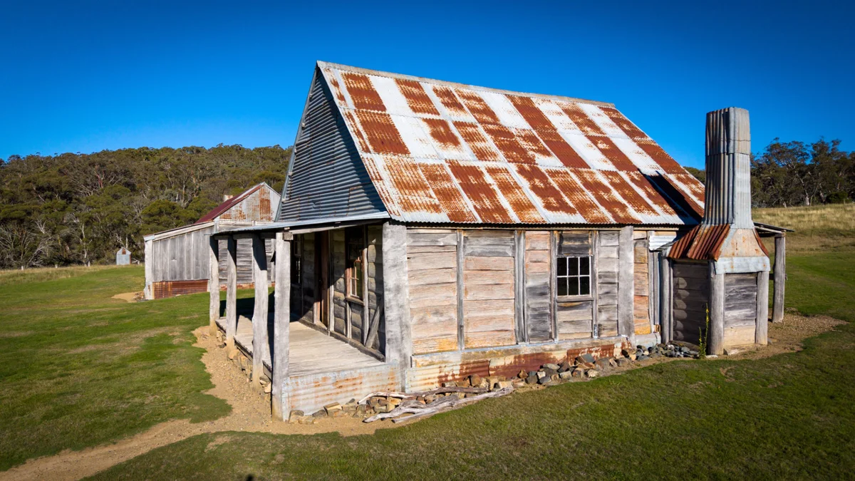
Moolooloo has history. John McDouall Stuart departed from the station yards in 1861 on his final and successful south-to-north crossing of the continent. The old homestead is still standing. It's the kind of place where it's worth slowing down for an hour.
We camped at 3rd Waters, a remote site on the station. Firewood was scarce — you had to walk several hundred metres to find any. The shower was available at the shearers quarters near the homestead; keep it short, the station runs on rainwater.
Nuccaleena Mine is accessible via a public access route (PAR) on pastoral land. Copper was discovered by William Fink in the mid-1850s. By early 1860, 16 men had mined 100 tonnes of copper ore in five weeks. By 1861, 86 men were employed. By 1866, the mine had produced £13,000 worth of copper after spending £57,000 on the enterprise, and was abandoned. The ruins are extensive and include stone buildings, a former township, and a lot of context about what it took to run an operation in this country in that era.
Ferguson Gorge is a 3.5km medium walk from the station, clearly marked. Access requires permission and a fee paid to Moolooloo Station — worth it. The Blinman Hut is a remote stone accommodation option also bookable through the station, with a fireplace and outdoor dunny but no beds or bedding. It's at least three hours over rough terrain from the next town. Take a PLB.
For navigation throughout the trip I used Memory Maps for All as the primary app. In this part of the Flinders it had noticeably better coverage and map detail than Explorers, particularly for named features and track info. The ability to run multiple maps and swap between them in the same app is useful when you're in an area where one map set fills gaps that another misses. If you want to pick up the Hema 4WD map set, that link gives you 10% off the price.
The Copper Track and Mt Gill at Warraweena
We had special permission from both stations to approach Warraweena from the south via the copper track — normally this runs one way from the other direction and isn't on any map. The directions were verbal. Large sections of it don't exist on Memory Maps for All or Explorers. You navigate by compass heading and hope the tracks you're following go where you think they go.
The track isn't technically difficult, but it's remote in a different way to most 4WD trips. You are further from the next person here than you would be on most lines through the Simpson Desert. That's not hyperbole — it's a useful reference point for how to prepare.
The scenery along the copper track is outstanding. Ancient creek beds, rock pools, gorges, colour changing as the light moves. It's one of the more scenic drives I've done in the Flinders Ranges.
Warraweena itself — the news at the time was that the trustees had decided not to renew manager Stony's lease and were closing the tracks to the public. Mt Gill was likely to be the last time it was recorded on video.
The Mt Gill track is 36km, classified hard on the Warraweena website. It starts through narrow dry creek beds — loose rocks, side angles, rock steps, low-hanging trees. Anything with a rooftop tent needs to watch clearance in several spots. It's narrow enough that a Unimog would struggle, and we were already tight.
The second stage climbs to 900 metres above sea level on narrow ridgebacks, with views across to Wilpena Pound from the top. Steve's near-stock TroopCarrier on BFG K02s made it up with careful wheel placement. Outside the Bendleby Ranges, Mt Gill is one of the most interesting station tracks in the Flinders. The closure is a real loss.
We also stopped at the Katnia mine ruins near Warraweena — copper discovered in 1870, a township of up to 400 miners at peak, flooded and abandoned in 1877. Two cemeteries remain. Black Springs, the signature campsite on the property, has permanent water and is worth a night if access ever returns.
After Warraweena we headed for the Oodnadatta Track, then the Simpson Desert.
Watch the full 2022 Flinders Ranges series on the AllOffRoad YouTube channel.